National Weather Service warns of hazardous travel, falling snow levels and a prolonged cold snap through Thursday
Ashland.news staff report
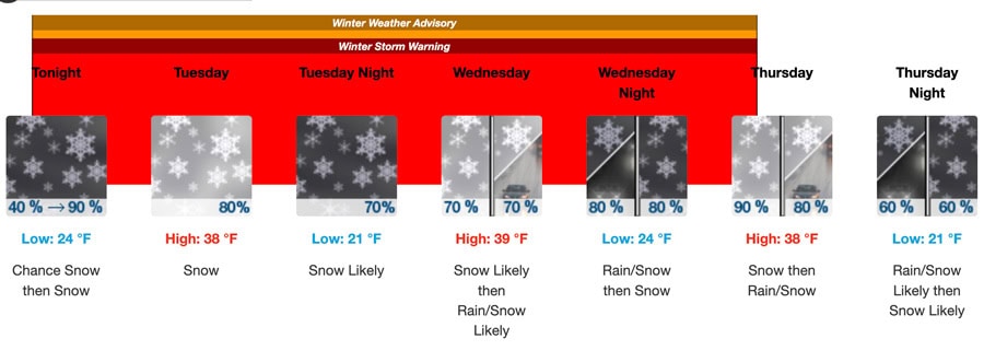
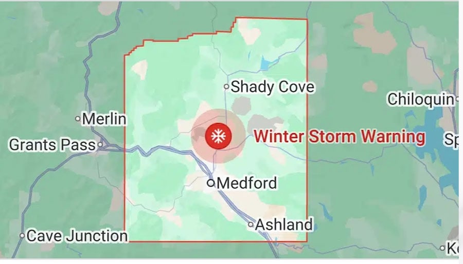
A winter storm warning that went into effect at 10 p.m. Monday, Feb. 16, continues to 10 a.m. Thursday, Feb. 19, for mid- to higher elevation parts of Jackson County according to a news release from the National Weather Service issued Sunday morning, Sunday, Feb. 15. A winter weather advisory is in effect over the same time period for areas up to 2,000-foot elevation.
Update: Due to snow, the SOU Ashland campus will be closed Tuesday Feb. 17
Forecasters said periods of snow are expected Monday through Thursday, with total accumulations forecast at 3 to 6 inches below 2,000 feet and 4 to 12 inches at 2,000 feet and above, according to an updated forecast issued Monday evening. Downtown Ashland is at about 2,000 foot elevation.
The advisory warns that road conditions could become hazardous, particularly on bridges, overpasses and untreated secondary roads. Hazardous conditions could impact the Tuesday morning and evening commutes, according to Monday evening’s updated forecast, which said travel may be very difficult to impossible.

A sharp cold front is expected to push through the region Monday night into Tuesday morning, ushering in a cold air mass that will linger through at least Thursday, forecasters noted. Snow levels are expected to drop quickly from around 3,000 feet Monday to between 1,000 and 1,500 feet late Monday night into early Tuesday.
Multiple waves of precipitation are expected to move through the region while the colder air mass remains in place, bringing several opportunities for low-elevation snow, the weather service said.
The weather service described the system as a “long-duration event.” After the initial front passes Monday night, precipitation is expected to become more showery, resulting in periods of spotty and quick accumulations.
Snowfall totals reflected in the forecast are calculated over a three-day period from 10 p.m. Monday through 10 p.m. Thursday, the release said.
According to the weather service, higher temperatures are expected to push snow levels up to around 2,000 to 2,500 feet during the day before dropping again in the evening. The best chance of accumulating snow down to valley floors will be during the overnight and early morning hours.
Forecasters said drivers should slow down and allow extra time to arrive at destinations. Officials also encourage motorists to carry an extra flashlight, food and water as well as tire chains. People should also monitor updated forecasts as conditions may change throughout the week. Call 511 or go to tripcheck.com for road information.
Ashland severe winter shelters to open
The city’s severe-weather winter shelter at 2200 Ashland St., and an additional shelter at 2350 Ashland St., will open beginning the evening of Monday, Feb. 16, through Wednesday, Feb. 18, according to a severe weather notification. Both locations are managed by Opportunities for Housing, Resources & Assistance (OHRA).
Email Ashland.news associate editor Steve Mitchell at stevem@ashland.news.
Feb. 16: Updated with forecast information as of Monday evening.


